 Catalogue PIGMA
land cover
Type of resources
Available actions
Topics
Keywords
Contact for the resource
Provided by
Years
Formats
Representation types
Update frequencies
Scale
Resolution
-

The Coastal Zones LC/LU Change (CZC) 2012-2018 is providing the Land Cover / Land Use (LC/ LU) change for areas along the coastline of the EEA38 countries and the United Kingdom, between the reference years 2012 and 2018. The Coastal Zones product monitors landscape dynamics in European coastal territory to an inland depth of 10 km with a total area of approximately 730,000 km², with all the relevant areas (estuaries, coastal lowlands, nature reserves). The production of the coastal zone layers was coordinated by the European Environment Agency (EEA) in the frame of the EU Copernicus programme, as part of the Copernicus Land Monitoring Service (CLMS) Local Component. The Coastal Zones Change product covers a buffer zone of coastline derived from EU-Hydro v1.1. The Land Cover/Land Use (LC/LU) Change layer is extracted from Very High Resolution (VHR) satellite data and other available data. The reference years for the change are 2012 and 2018. The class definitions follow the pre-defined nomenclature on the basis of Mapping and Assessment of Ecosystems and their Services (MAES) typology of ecosystems (Level 1 to Level 4) and CORINE Land Cover adapted to the specific characteristics of coastal zones. The classification provides 71 distinct thematic classes with a Minimum Mapping Unit (MMU) of 0.5 ha and a Minimum Mapping Width (MMW) of 10 m. The status product is available for the 2012 and 2018 reference years. This CZC dataset is distributed in vector format, in a single OGC GeoPackage file covering the area of interest. You can read more about the product here: https://land.copernicus.eu/en/products/coastal-zones/coastal-zones-change-2012-2018.
-

The Coastal Zones (CZ) LC/LU product for 2018 is providing a detailed Land Cover / Land Use (LC/ LU) dataset for areas along the coastline of the EEA38 countries and the United Kingdom, with reference year 2018 for the classification. This product monitors landscape dynamics in European coastal territory to an inland depth of 10 km with a total area of approximately 730,000 km², with all the relevant areas (estuaries, coastal lowlands, nature reserves). The production of the coastal zone layers was coordinated by the European Environment Agency (EEA) in the frame of the EU Copernicus programme, as part of the Copernicus Land Monitoring Service (CLMS) Local Component. The Coastal Zones product covers a buffer zone of coastline derived from EU-Hydro v1.1. Land Cover/Land Use (LC/LU) layer is extracted from Very High Resolution (VHR) satellite data and other available data. The class definitions follow the pre-defined nomenclature on the basis of Mapping and Assessment of Ecosystems and their Services (MAES) typology of ecosystems (Level 1 to Level 4) and CORINE Land Cover adapted to the specific characteristics of coastal zones. The classification provides 71 distinct thematic classes with a Minimum Mapping Unit (MMU) of 0.5 ha and a Minimum Mapping Width (MMW) of 10 m. The product is available for the 2012 and 2018 reference year including change mapping. This CZ dataset is distributed in vector format, in a single OGC GeoPackage SQLite file covering the area of interest. You can read more about the product here: https://land.copernicus.eu/en/products/coastal-zones/coastal-zones-2018.
-
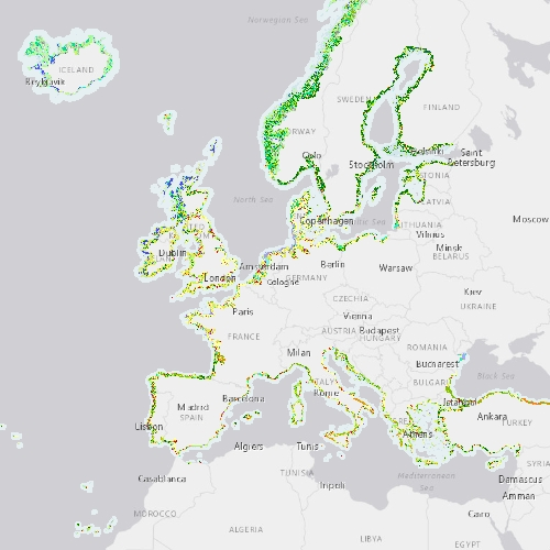
The Coastal Zones (CZ) LC/LU product for 2012 is providing a detailed Land Cover / Land Use (LC/ LU) dataset for areas along the coastline of the EEA38 countries and the United Kingdom, with reference year 2012 for the classification. This product monitors landscape dynamics in European coastal territory to an inland depth of 10 km with a total area of approximately 730,000 km², with all the relevant areas (estuaries, coastal lowlands, nature reserves). The production of the coastal zone layers was coordinated by the European Environment Agency (EEA) in the frame of the EU Copernicus programme, as part of the Copernicus Land Monitoring Service (CLMS) Local Component. The Coastal Zones product covers a buffer zone of coastline derived from EU-Hydro v1.1. Land Cover/Land Use (LC/LU) layer is extracted from Very High Resolution (VHR) satellite data and other available data. The class definitions follow the pre-defined nomenclature on the basis of Mapping and Assessment of Ecosystems and their Services (MAES) typology of ecosystems (Level 1 to Level 4) and CORINE Land Cover adapted to the specific characteristics of coastal zones. The classification provides 71 distinct thematic classes with a Minimum Mapping Unit (MMU) of 0.5 ha and a Minimum Mapping Width (MMW) of 10 m. The product is available for the 2012 and 2018 reference year including change mapping. This CZ dataset is distributed in vector format, in a single OGC GeoPackage SQLite file covering the area of interest. You can read more about the product here: https://land.copernicus.eu/en/products/coastal-zones/coastal-zones-2012.
-
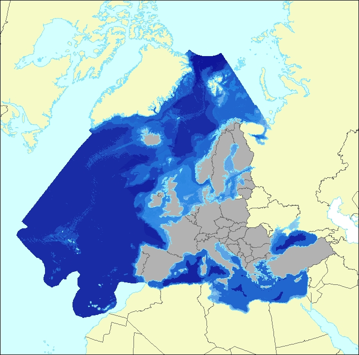
The data set aims to contribute to a better biological characterization of European marine ecosystems. As such it represents probabilities of EUNIS (EUropean Nature Information System) habitat presence at Level 3 for marine habitats including information on sea ice coverage (this corresponds to EUNIS level 2 for terrestrial habitats). The map combines spatially explicit data on marine bathymetry and sea-bed with non-spatially referenced habitat information of the EUNIS classification. The objective of the data set produced by EEA and its Topic Centre ETC/ULS is to improve the biological description of marine based ecosystem types and their spatial distribution. The work supports Target 2 Action 5 of the implementation of the EU Biodiversity Strategy to 2020, established to achieve the Aichi targets of the Convention of Biological Diversity (CBD). It further addresses the MAES process (Mapping and Assessing of Ecosystems and their Services). The data set represents 2 classes of the MAES classification level 3, namely “Marine inlets and transitional waters” and “Marine”. The dataset comprises the following information: • Sea region (1 – Arctic, 2 – Atlantic, 3 – Baltic, 4 – Mediterranean, 5 – Black Sea) • Sea zone (1 – Littoral, 2 – Infralittoral, 3 – Circalittoral, 4 – Offshore circalittoral, 5 – Upper bathyal, 6 – Lower bathyal, 7 – Abyssal,8 - Coastal Lagoons, 9 - Coastal Lagoons) • Substrate (0 – undetermined substrate, 1 – rock and biogenic, 3 – coarse sediment, 4 – mixed sediment, 5 – sand, 6 – mud) • Sea ice coverage (0 – no sea ice presence, 1 – seasonal sea ice presence, 2 – perennial sea ice presence)